


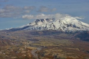
On May 18, 1980, Mount Saint Helens, which once stood 9,677 feet above sea level, experienced a violent eruption. The eruption took 1,310 feet off the top of this gorgeous mountain and triggered the largest recorded landslide, shooting the entire side of the mountain at supersonic speeds to the north. The blast flattened everything standing for six miles. All total, 57 people died, with countless others injured as their homes were destroyed by lahars down every river and stream.
 The landscape forever changed that day. For decades, the majority of the region surrounding this once beloved recreation area was ignored, overlooked and forgotten. Now, with vegetation returning and the region once again open for exploration, the greater Mount Saint Helens area offers incredible hikes and views for the entire family. Whether you wish to scale the summit in the winter snow or hike underground in an old lava tube, Mount Saint Helens is your go-to destination for incredible adventures.
Hikes and Views around the Mountain
While the classic Mount Saint Helens hikes and views from areas like Lava Canyon, Windy Ridge and Harry’s Ridge may be inaccessible due to winter conditions, the iconic and famous volcano still has some epic views to be found. In the winter, when most of the remote Forest Service Roads are closed and inaccessible, Mount Saint Helens still shows off her pretty and ever-growing summit from the breathtaking drive along Highway 504, known as the Spirit Lake Highway.
Starting either at Toledo or Castle Rock, the road heads east, straight toward the mountain. Offering numerous view points and seasonal visitor centers, this road is the perfect reintroduction to this incredible region. While the final stretch of the road to the Johnston Ridge Observatory isn’t open until the spring, you can drive all the way to Coldwater Lake, just nine miles away. Along the drive, watch for elk and witness the power of the blast zone, which is marked by numerous signs.
Once at Coldwater Lake, park at the lower parking area and take a walk along the trails. Showcasing the beauty of the Pacific Northwest, it is one of several lakes in the area that were created by the eruption. Coldwater Lake was formed during the 1980 eruption of Mount Saint Helens, when the blast blocked Coldwater Creek with volcanic debris. Surrounding the lake are huge ridges rising up from the shore over 1,000 feet in height.

To best experience and learn about the lake, take the half mile Birth of a Lake Trail, complete with a boardwalk that makes the trail accessible to all. In extremely cold weather, the lake may be partially frozen with tons of snow around, making the short loop incredibly perfect for solitude and getting reconnected with the sound of silence. Those looking for more of a hike than a short walk will love the Lakes Trail. This 8.3 mile out-and-back hike takes you to the Mount Margaret backcountry beyond the lake, but you don’t have to take it all in to enjoy the quiet and beautiful region. One mile in and you’ll be alone along the shore, where jaw-dropping views await.
Go Underground
Underground, a family adventure is waiting for you that is one of the most unique things you can do in the Pacific Northwest. Around 2,000 years ago, Mount Saint Helens had an eruption that poured lava down its sides in huge streams. As the lava flowed farther from the source of magma, it started to cool around the edges, forming a long tube where liquid hot magma still was flowing through its natural piping. As the lava flow ceased, the pipe emptied, creating a 13,042 long lava tube.

For 2,000 years, the cave was hidden, until 1951, when Harry Reese and his sons found an opening to the lava tube and explored the cave. They named it the Ape Caves after their outdoor club, the Mount Saint Helens Apes, and for the past 65 years, it has been a favorite year-round destination.
In the winter, the road to the Ape Caves visitor center is closed, forcing you to walk a mile to the entrance. Don’t let this stop you though. Once inside, the cave is 42 degrees year round and offers two trails for exploration. The best bet for a quick, winter trip is to take the short Lower Cave Trail, which is 1.5 miles round trip. While this may seem short, 1.5 miles underground can seem like an eternity, so be patient and enjoy the slow walk. The Upper Cave trail is 1.2 miles one way and has narrow openings and steep sections. Make sure that when you visit the Ape Caves that you bring proper clothing, as well as a flashlight or two per person with extra batteries. Also, be aware that the cave will be wet, as groundwater seeps through small cracks on the top of the cave.
Hike to the Crater Rim

Finally, no Mount Saint Helens experience would be compete without talking in the amazing landscape from the top of the crater rim. During the winter months, once the snow is settled and secure, the summit can be reached via the Worm Flows Route from the Marble Mountain Sno-Park area. This is a beast of a hike, requiring you to be in good shape and have proper winter gear, like warm clothes, route finding skills and crampons.
Gaining 5,700 feet in six miles, the word steep doesn’t properly justify the ascent up this iconic volcano. In total, the Worm Flows Winter Climbing Route is 12 miles round trip and will take you all day. Offering spectacular views of the entire region, including a look directly into the steaming crater of the mountain, standing atop the summit is one of the best ways to gain a true appreciation for the majesty that still remains at Mount Saint Helens. To climb this peak, please look at this link and contract the National Forest Service. A permit is required to climb Mount Saint Helens from April 1 – November 1, making the winter months the perfect time to summit for free.


